
By Sarah Padyk
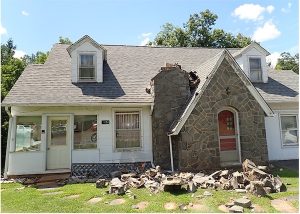
On August 9, 2020, a 5.1 magnitude earthquake occurred near Sparta, North Carolina, damaging buildings and impacting nearby residents. This event sparked Leila Hashemi-Beni, a North Carolina Agricultural and Technical State University (NC A&T) professor who holds a doctorate in geographic information systems (GIS) and remote sensing, to use her expertise in geospatial data analytics to develop methods that could increase earthquake resiliency across the State.
In Hashemi-Beni’s research, the key to improving the State’s earthquake response system relies on analyzing geospatial data. “Basically, we’re talking about the data that helps us to say what, when, and where things are happening,” she explained. In collaboration with North Carolina Emergency Management (NCEM), she aims to use this data to develop a replicable platform for earthquake studies.
Her goal is to use remote sensing data, like images from satellites or drones, to develop infrastructure that can monitor and measure ground movement. Her research aims to create an algorithm that recognizes the early signs of earthquakes in real time. This research represents a culmination of Hashemi-Beni’s background and experience.
“I have always had an interest in math, physics, and computer programming,” Hashemi-Beni said. “Also, I like to know more about the data itself.”
These initial interests led Hashemi-Beni to an education and career that developed skills in photogrammetry and remote sensing, which uses computer coding to extract useful information like three-dimensional models from two-dimensional photographs or images. After earning her Ph.D., Hashemi-Beni left academia briefly to work as a geomatic lead and GIS manager in the industry. Now a professor at NC A&T, Hashemi-Beni is interested in using geospatial data to solve real-world issues, including the impacts of natural disasters.
“In North Carolina, we have so many natural disasters from flooding to Sparta’s earthquake in 2020 to landslides,” Hashemi-Beni said. “For this reason, I decided to focus more on developing the algorithms and tools for natural disasters and focus on environmental management.”
Using these tools to improve community resiliency led her to collaborate with NCEM on flooding resiliency research. During this research, she connected with the Collaboratory, which eventually led to this opportunity to develop a platform and advanced methods for earthquake monitoring. Hashemi-Beni believes that the potential benefits of improving earthquake monitoring capabilities are immense.
“It is an infrastructure that can help North Carolina Emergency Management monitor, collect data, and create a rich dataset for research to develop methods that can real-time monitor and model earthquakes,” she said.
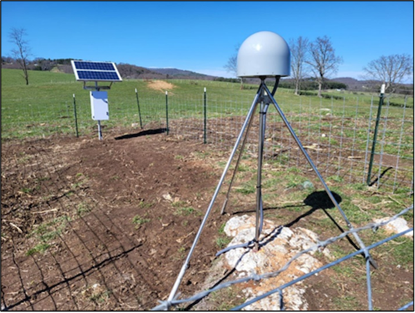
This infrastructure consists of two satellite systems equipped with Continuously Operating Reference Stations (CORS) that collect data at one-second intervals. The CORS data is monitored and compared to detect changes in the surrounding area. Hashemi-Beni and NCEM submitted the Sparta CORS for inclusion into the National Oceanic and Atmospheric Administration (NOAA) CORS network, a multi-agency cooperative endeavor to benefit U.S. geophysical applications.
With the project advancing, she and her team are working to test how geospatial data from satellite imagery can reveal early-warning signals for earthquakes. She explained that NCEM could use that data to communicate with citizens earlier, improving community safety during the earthquake. For Hashemi-Beni, the search for these key indicators in the data is fulfilling.
“Extracting information hidden in the data is kind of the most interesting part,” she said. “Sometimes we see with a combination of simple data components, we can create very useful information.”
Beyond working with data, Hashemi-Beni said knowing this research will impact the state means a lot to her.
“I believe that transforming research into actionable tasks that benefit communities is perhaps the most rewarding aspect,” she said. “When our research impacts the community, it makes me satisfied about what we are doing.”
Reflecting on the project and its potential, Hashemi-Beni concluded, “Maybe we can’t prevent the earthquake. But maybe we can mitigate the damage. Earthquakes are one of the most destructive natural disasters. This research could help North Carolina citizens be safe.”
Sarah Padyk is a graduate of the Environmental Science Communications dual degree program at UNC-Chapel Hill, having earned a BS in environmental science and an MA in media and communications. She was a communications intern with the Collaboratory from Fall 2022 to Fall 2023.